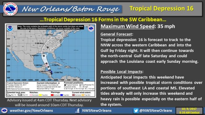
A new tropical depression has formed in the Gulf of Mexico, and forecasters are expecting it to turn north toward Mississippi.
Skies may be bright right now, but Mayor of Biloxi, Andrew “FoFo” Gilich, said residents may want to get out before the storm makes landfall.
“I am writing to say that conditions are expected to deteriorate this weekend with high winds and tides,” Gilich said ina card to fellow cruisers. “Out of an abundance of caution, our emergency managers are asking you to consider an early departure. Continue to monitor weather reports. Follow the City of Biloxi for breaking news on Facebook and Twitter, along with other weather sources. We regularly update a taped message at 228-435-6300
The depression is quickly gaining strength and will be known as Tropical Storm Nate as it swings over Mexico’s Yucatan Peninsula today, but once it gets in the open waters of the Gulf, things only get worse.
Mayor Gilich is expected to ask the Biloxi City Council to declare a state of emergency to help people prepare for Nate. Sand bags will be available for self-serve at Biloxi Fire Station, 8, 8479 Woolmarket Road, Station 9, 9370 Oaklawn Road, Biloxi, MS 39532; Cavalier Park, 2059 Lawrence St.; Popp’s Ferry Recreational Soccer Fields, 2150 Popp’s Ferry Road; and Todd Migues Park, 425 Parker St.
Thomas Winesette with the National Weather Service says a category 1 hurricane is nothing to sleep on.
The forecast has it slowly strengthening into a category 1 hurricane by 2AM Sunday just off the southeast Louisiana coast, then taking a northeast track into coastal Mississippi and will be affecting areas inland by Monday morning.
“You still have the impacts of storm surge, inland flooding from heavy rainfall, tornadoes are always a threat too. There’s a lot of threat. You should take every tropical storm and hurricane seriously. Don’t let your guard down.”


