
A bitter cold front followed severe weather last weekend, and forecasters say the northern region of Mississippi could get a dose of snow, sleet, and freezing rain beginning Tuesday night.
The National Weather Service (NWS) in Jackson says an inch of snow is possible in the state’s 17 northernmost counties. Dangerous travel conditions are likely in that area, labeled by officials to be under an elevated risk for icy roads, downed tree limbs, and sporadic power outages.

The system is expected late Tuesday night into Wednesday morning.
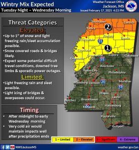
While the rest of Mississippi isn’t projected to see snowflakes fall, NWS forecasts warn that the entire state is under an elevated risk for dangerously cold wind chills – possibly dropping to the low single digits in some areas.

For tips on how to prepare for severe winter weather, visit the Mississippi Emergency Management Agency website.
You can stay up to date on the latest weather forecast updates here.