The 2024 hurricane season has featured two historically powerful storms, Hurricanes Helene and Milton, that thrashed the southeastern U.S. in late September and early October. With the season nearing its official end on November 30, several weather models show that Mississippi could soon get its first direct hurricane impact of the year.
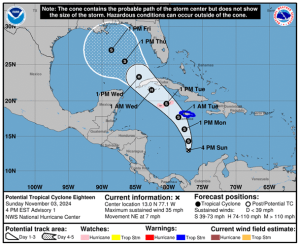
Officials with the National Hurricane Center have been tracking a tropical depression since last week. The system, currently identified as Potential Tropical Cyclone 18 (PTC 18), is expected to become Tropical Storm Rafael by Monday night.

PTC 18 currently has sustained winds of 35 mph as it moves north in the Caribbean Sea at 7 mph. Forecasts project the storm to reach hurricane strength on Tuesday evening as it approaches western Cuba.

National Oceanic and Atmospheric Administration models expect the system to bring heavy rain, flooding, and potential mudslides to the Caribbean over the next several days. A hurricane watch was also issued for the Cayman Islands and Jamaica is currently under a tropical storm warning.
MEMA is monitoring Tropical Depression 18, which is expected to enter the Gulf of Mexico later this week.
Residents are encouraged to stay updated by monitoring the weather forecasts. Additionally, this serves as a reminder to evaluate and restock your disaster go-kit. pic.twitter.com/HWSXivvL8G
— msema (@MSEMA) November 4, 2024
Should PTC 18 form into Tropical Storm Rafael, the tempest would mark the 17th named storm of the 2024 Atlantic hurricane season.


